Introduction and Definition of Terms
The Oxford Dictionary of the English Language defines geography as “the description of the earth’s surface.” Its Greek root words, geo– and graphein, literally mean “earth writing.” Maps are defined as “a representation, usually on a flat surface of the whole or a part of an area.” The English word “map” is a shortened version of the French mappamonde, derived from the Latin phrase mappa mundi, or “sheet (napkin) of the world.” Maps might hence be defined as a “textual” product of geography. Thus as a “written” representation, maps might be described as something “scribed” upon landscape — an imposition. The cultural and historical implications of maps (and hence geography) as a means of representation entail an enormous amount of power. Maps and geographical representation have influenced the power relationships between European nations and their colonies and have likewise revealed the nature of these power relationships. As such, maps play a significant role within postcolonial theory and the postcolonial novel. (See Maps in Colonialism.)
The Evolution of the Map and the Discipline of Geography
The Babylonians leave us with the oldest examples of attempts to chart the cosmos and represent it geographically; the oldest example is a cadastral plan of the city of Babylon dating back to 2200 BCE. The Babylonians were also the first to apply the four cardinal points that we now know as north, south, east, and west. The Egyptians also leave evidence of early mapping, including the famous Turin Papyrus, a sketch of an Egyptian gold mine (Tooley 3). However, the Greeks are considered to be the founders of geography as a scientific discipline. In the second century BCE, Crates created the first globe, a spherical representation of the Earth, and even today, the globe is considered to be the most spatially accurate depiction of the Earth. Indeed, early Greek cartographers struggled with the dilemma of representing a spherical world on a flat surface. Hipparchus was the first to experiment with different forms of longitudinal and latitudinal projection, creating what we now know as the stereographic and orthographic projections. Both forms remain true to the shape of landmasses, but the stereographic projection distorts the scale of the map by making the peripheral latitudes too large in relation to the central ones. The orthographic projection does the reverse. These early “geographers” can certainly be cited as the first mapmakers, yet it is the philosopher Eratosthenes who is considered to be father of geography as a discipline. He was the first cartographer to estimate the circumference of the earth by measuring the shadow of the sun at Alexandria and Syene, which he assumed to be on the same meridian. Modern technology has found his estimate to be fairly accurate. Much of our knowledge of these early Greek geographers comes from Geographia, published by the Roman scribe Strabo in the first century BCE (James 21-48).
The Emergence of Mapping as an Art form
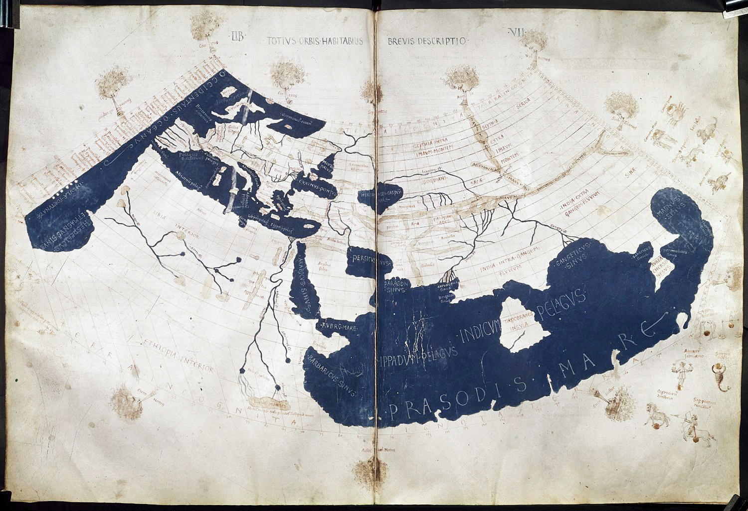
The era of ancient geography drew to a close when Ptolemy published his eight volume Guide to Geography in the second century of the Common Era. However, Ptolemy marked the beginning of a tradition of misguided and unfounded geographical theories that held dominance for the next 1500 years. He asserted that the earth was the stationary center of the universe and concluded that regions of the earth near the equator were uninhabitable due to strenuous heat. He also vastly underestimated the breadth of space separating the Western coasts of Europe from Asia. He assumed that the entire span was taken up by ocean, and thus Columbus assumed he had arrived in Asia upon “discovering”the Americas in 1492. Yet perhaps the most poignant legacy of Ptolemy is the establishment of map-making as an art. Whereas his predecessors left unexplored regions blank on their maps, Ptolemy filled these blanks with theoretical conceptions, a tradition which later mapmakers followed by inserting fantastic monsters or cannibals to represent unexplored continents such as Africa and the Americas (Tooley 5-8).
With the fall of the Roman Empire, very few advances were made in the science of geography, and it increasingly became an art of mythical speculation. Ptolemy’s theories dominated until the Renaissance. The next monumental leap in map-making came in 1538, when Mercator published his first map of the world. Put simply, this map depicted the world as two heart-shaped “pictures” of a globe (one from the northern pole, the other from the southern pole). Today this type of representation is known as a spherical projection; it is the closest two-dimensional projection of the earth to the ideal globe. The map soon became the most common depiction of the earth as a whole. However, an age of exploration was dawning in Europe and his map was largely impractical for navigators. His later map, published in 1569, was the first example of the more practical mercator projection. This map largely distorted the scale of land masses as they approached the poles, yet the longitudinal and latitudinal meridians followed a straight-line grid pattern throughout the world. This grid allowed oceanic navigators to chart courses on a map using straight lines rather than curves line, and the map became the most widely used projection for navigating near the equator (James 102-110).
For the next 400 years, the science of map-making progressed largely through extensive exploration and advances in technology that gave European cartographers a closer look at areas previously unexplored. “Islands” such as Florida and India were revealed to be peninsulas, and monsters and cannibals gave way to colonies and new territorial boundaries. However, geography and the power to map were increasingly used by European colonial powers to assert dominance over much of the world.
The Geography of Imperialism and Map-making
Creating accurate maps was essential to colonial powers in order to chart trade routes and establish colonies beyond the familiar boundaries of Europe (see Gilroy: The Black Atlantic, The Spice Trade in India). Maps also allowed European powers to assess the regions that they controlled and the potential resources contained within them. Accurate knowledge of geography and the physical boundaries of the earth entailed with it the power to draw political boundaries and thus establish colonial territories. David Turbull compares European maps with “primitive” Australian aboriginal maps and comes to several conclusions concerning the relationship between the power to map and the power to control:
[T]he real distinguishing characteristic between Western maps is that they are more powerful than aboriginal maps, because they enable forms of association that make possible the building of empires, disciplines like cartography and the concept of land ownership that can be subject to juridical processes. (55)
Turbull also points out the means by which various projections with different spatial distortions might be favored over one another because of the regions that they emphasize. For instance, in the famous Mercator projection, Britain and Europe appear relatively large compare to most of the colonized world. The use of such means of geographic representation may not be an overt assertion of power, yet its influence on how regions and nations are perceived is undeniable (7-9). Thus the power to map was crucial to the power of European nations to control much of the world: to map at least in part implies claiming it (Livingstone 24-30). (See also Architecture and Colonialism, Apartheid.)
Postcolonialism and “De-Mapping” the Empire
The end of imperialism in the twentieth century left behind an enormous legacy of imposed geography and a myriad of newly independent nations drawn upon the territorial lines of colonialism. Many contemporary geographers have sought to reestablish geography as an objective science in order to create less biased representations of landscape. Aviation and satellite technology have allowed us to see our planet on a grand scale, as we never have before (Hanson 145-150). Likewise, postcolonial theorists have sought to “de-map” nations formerly colonized and thereby shed a landscape imposed upon much of the world by Europe. Edward Said asserts that the “slow and often bitterly disputed recovery of geographical territory which is at the heart of decolonisation is preceded — as empire had been — by the charting of cultural territory” (252). Thus, he is asserting that “decolonisation” seeks to shed the political boundaries imposed upon colonies by Europe in favor of a geography that complements the cultural “geography” of nations. Maps are a representation, and as such, they must be understood in relation to whose perspective they are representing as opposed to simply what (or where) they are representing.
However, Richard Phillips asserts that the evolution of maps does not follow a necessarily linear progression, stating that while newer maps are “generally more crowded, successive maps [are] not necessarily more truthful” (6). Thus, despite the efforts of geographers, perhaps maps are ultimately inescapable from their condition as a representation of human design and therefore a representation of human bias. Today technology has given us maps that come perhaps as close as possible to spatial accuracy, yet we still have the power to impose our own will upon this spatial landscape and manipulate its representation to suit biased needs (James 505-510).
Works Cited
- Hanson, Susan. Ten Geographic Ideas that Changed the World. New Brunswick: Rutgers University Press, 1997.
- James, Preston E. All Possible Worlds: A History of Geographical Ideas. Indianapolis: Odyssey Press, 1972.
- Livingstone, David N. The Geographical Tradition: Episodes in the History of a Contested Enterprise. Oxford: Blackwell, 1992.
- Oxford English Dictionary. Second Ed. Oxford: Oxford University Press, 1989.
- Phillips, Richard. Mapping Men and Empire: A Geography of Adventure. London: Routledge, 1997.
- Said, Edward. Culture and Imperialism. London: Vintage, 1993.
- Tooley, R.V. Maps and Map-Makers. London: B.T. Batsford, 1949.
- Turnbull, David. Maps are Territories: Science is an Atlas. Chicago: University of Chicago Press, 1987.
Suggested Reading
- Blunt, Alison and Cheryl McEwan. Postcolonial Geographies. New York: Continuum, 2002.
- Brotton, Jerry. Trading Territories: Mapping in the Early Modern World. Ithaca: Cornell University Press, 1998.
- Brown, Lloyd A. The Story of Maps. Boston: Little, Brown & Co., 1949.
- Edney, Matthew H. Mapping an Empire: The Geographical Construction of British India, 1765-1843. Chicago: University of Chicago Press, 1997.
- Huggan, Graham. Interdisciplinary Measures: Literature and the Future of Postcolonial Studies. Liverpool: Liverpool University Press, 2008.
- Kish, George. A Source Book in Geography. Cambridge: Harvard University Press, 1978.
- Mallory, William E. & Paul Simpson-Housely eds. Geography and Literature: A Meeting of the Disciplines. Syracuse: Syracuse University Press, 1987.
- Massey, Doreen & John Allen eds. Geography Matters! A Reader. Cambridge: Cambridge University Press, 1984.
- McClintock, Anne. Imperial Leather: Race, Gender and Sexuality in the Colonial Contest. New York: Routledge, 1995.
- Moreland, Carl & David Bannister. Antique Maps. Oxford: Phaidon,1986.
- Sarmento, João. Fortifications, Post-Colonialism and Power: Ruins and Imperial Legacies. Farnham: Ashgate Publishing Limited, 2011.
- Staeheli, Lynn A. and Eleonore Kofman, Linda Peake. Mapping Women, Making Politics: Feminist Perspectives on Political Geography. Ed. Staeheli, Lynn A. and Eleonore Kofman, Linda Peake. New York: Routledge, 2004.
- Stoddart, D.R. On Geography and its History. Oxford: Basil Blackwell,1986.
- Thrower, Norman J.W. Maps and Man: An Examination of Cartography in Relation to Culture and Civilization. Englewood Cliffs: Prentice-Hall,1972.
- Whitfield, Peter. New Found Lands: Maps in the History of Exploration. New York: Routledge, 1998.
- The Image of the World: 20 Centuries of World Maps. London: The British Library, 1994.
Postcolonial Novels and Poetry to Consider
- Calvino, Italio. Invisible Cities. Rome: Giulio Einaudi Editore, 1972.
- Farah, Nuruddin. Maps. London: Pantheon, 1986.
- Kincaid, Jamaica. A Small Place. New York: Farrar, Straus and Giroux, 1988.
- Nourbese Philip, Marlene. Looking for Livingstone: An Odyssey of Silence. Toronto: The Mercury Press, 1991.
- Vladislaviċ, Ivan. Portrait with Keys: The City of Johannesburg Unlocked. London: W.W. Norton & Co, 2009.
Links to Related Sites
- The Association of American Geographers, http://www.aag.org/
- British Library Digital Collection Database, http://www.britishmuseum.org/research/search_the_collection_database.aspx
- The Mercator Atlas of Europe, http://www.walkingtree.com/
- National Geographic “Map-Machine”, http://www.nationalgeographic.com/resources/ngo/maps/
- Map Collections of the Library of Congress, http://memory.loc.gov/ammem/gmdhtml/gmdhome.html
- Yale Map Collection, http://www.library.yale.edu/MapColl/print_online.html
Author: Nathan White, Spring 1999
Last Updated: October 2017
2 Comments
Pingback: Ways of Seeing the World – The Quindecim
Pingback: Nepal’s Geostrategic Location: A Postcolonial Perspective - Sino Sphere