Introduction
The field of linguistic landscape research initially focused on traditional notions of physical signage such as posters, advertisements, and focused on factors like multilingualism (Backhaus, 2006) and linguistically contested areas (Lyons, 2017). Additional areas of interest are enclaves with a dominant cultural group (Lou, 2012) or places with institutional bilingualism (Vandenbroucke, 2015) or multilingualism (Zhang, 2020). Linguistic landscape research in these areas employ some sort of walking methodology in their data collection. Hult’s (2014) paper on “drive-thru” linguistic landscaping breaks this precedent of data collection on foot and validates a data collection methodology that records signage from a moving vehicle. Multicultural spaces that defy this walking method for data collection are of particular interest for a linguistic landscape project. Buford Highway in Dekalb County, Georgia fits this idea of a space best traversed by automobile. The site is not a neighborhood, but rather an industrial corridor that crosses different cities and counties within Georgia. I sought to employ a similar approach to Hult (2014) for studying multilingualism and place making along Buford Highway.
Buford Highway, also known as the Buford Highway corridor and the Dekalb International Corridor, consists of a seven-lane highway stretching across Fulton, Dekalb, and Gwinnett counties in northeastern Atlanta (What is Buford Highway?, 2011). The corridor, originating as a highway connecting railroad towns, saw the development of strip malls starting in the 1960s and 1970s. This was succeeded by an influx of immigrants into the area for affordable housing, access to public transportation, and access to construction jobs in nearby Gwinnett County. The area saw a further influx of foreign-born immigrants during the construction boom preceding the 1996 Olympics in Atlanta. Today, the area is known for its ethnic diversity, with many businesses catering to Mexican, Vietnamese, Chinese, Latino, and Korean communities around the area (What is Buford Highway?, 2011). Specifically, I focus on Brookhaven and Chamblee, two different cities connected by the corridor. I choose Brookhaven and Chamblee for multiple reasons. First, they are adjacent municipalities that both have a stretch of Buford Highway within their city limits. Additionally, both are involved with pedestrian infrastructure improvement projects along the highway in a multi-city initiative, with Brookhaven having finished one project in March 2025 (City of Brookhaven, 2025). Lastly, as Table 1 indicates, they have differing demographics.
Table 1: Census Tracts – based on 2020 Census estimates
Brookhaven
| Census Tract | 214.15 | 215.02 |
| Total Population | 4175 | 5503 |
| Foreign Born Population | 870 | 680 |
| Percentage Foreign Born | 20.84 | 12.36 |
| Top 3 Countries | India (185) Mexico (124) China (83) | Colombia (107) India (53) Cambodia (51) |
Chamblee
| Census Tract | 214.10 | 214.12 | 213.08 | 212.04 |
| Total Population | 5204 | 4050 | 4380 | 4205 |
| Foreign Born Population | 2514 | 388 | 1735 | 1483 |
| Percentage Foreign Born | 48.31 | 9.58 | 39.61 | 35.27 |
| Top 3 Countries | Mexico (1471) Guatemala (452) Ecuador (147) | Mexico (117) Russia (71) India (62) | Guatemala (710) Mexico (437) Vietnam (125) | Guatemala (1309) Mexico (300) Cuba (56) |
Due to revitalization efforts and its proximity to Intown and downtown Atlanta, Brookhaven has started to reflect a largely white, upper middle class demographic, while Chamblee has retained its majority minority and immigrant identity (U.S. Census Bureau, 2024).
In my study of Buford Highway, I referenced a few different papers. First, I referenced Lou’s (2012) study of Washington D.C.’s Chinatown and its examination of how design and development decisions within a bilingual landscape contribute to the cultivation of a cultural space. Lou’s (2012) site and approach provides a good reference for Buford Highway, where certain shopping plazas have designed the space to cater to different groups with shared cultural identities. I also referenced papers that used methodologies incorporating driving and photo-taking within their studies. Motschenbacher (2020) uses a daytime walk to collect data along Wilton Drive in Wilton Manors, Florida to understand how linguistic and non-linguistic signage function to create a homonormative space through critical discourse analysis. The paper provides a methodology reference for how to collect and annotate data while traveling through a space. Lastly, I referenced Hult’s (2014) drive-thru linguistic landscaping to understand how to document language within a space based on signage visible from an automobile. Hult’s “drive‑thru” analysis of San Antonio’s highway billboards shows how auto‑oriented infrastructures visually normalize English and relegate Spanish to limited niches, despite the city’s bilingual demographics. My work probes whether the same automotive dynamics reproduce English dominance or allow a more diverse, multilingual display. I seek to understand how signage visible from a moving vehicle creates meaning within space while driving. I propose a comparative study of two different sites along Buford Highway within the municipalities of Brookhaven and Chamblee. I hypothesize that Chamblee, which has more plazas catered to the surrounding immigrant communities, will have more linguistically diverse signage compared to those of Brookhaven.
Methods
I collected my data by taking pictures of signage along Buford Highway while my friend drove. We covered a 6 mile stretch of Buford Highway starting at the Buford Spring Connector near Lindbergh Drive in Brookhaven. My terminal point was the Asian Square shopping mall in Chamblee. Our drive covered the two municipalities of Brookhaven and Chamblee, starting at the edge of Brookhaven’s city limits along the highway and finishing through Chamblee. Of our drive, about 2.5 miles of the stretch was in Brookhaven while 3.5 miles of the stretch was in Chamblee. I conducted my data collection during midday on a Wednesday in mid-April to understand how visible signage during the daytime contributes to the identity of a space. In total, I collected 317 photos. During the coding process, I realized that while 317 photos gave me a rich number of photos to look at, it was not feasible to code all for the features present in my proposed analysis framework. I instead opted to look at a smaller subset of photos from both municipalities and I settled on coding the first 50 signs I saw in Brookhaven and Chamblee. From this modified approach, I gathered 100 total signs from 71 photos. Of these 71 photos, 25 photos were from Brookhaven and 46 photos were from Chamblee, resulting in an average of 2 signs per photo from Brookhaven and 1.09 signs per photo from Chamblee. For my identification of a sign, I used the definition put forth by Backhaus (2006) where I defined a sign as any body of text within a recognizable frame. For example, there were regulatory signs with symbols that I did not include by definition because of their lack of text. I categorized data by first providing a description for each sign and noting the language on each sign. I also coded for characteristics based on multiple frameworks. I used Scollon and Scollon’s (2003) framework of sign analysis to look at inscription and emplacement, looking at code preference and type of semiotics (situated, decontextualized, or transgressive), as well as Ben-Rafael’s (2006) idea of sign administration and authorship (top-down vs. bottom up) to round out my analysis.
Results
Tables 2-5 summarize the results of my data collection:
Table 2: Languages
| Language | Brookhaven | Chamblee | Total |
| English only | 48 | 33 | 81 |
| English+Spanish | 2 | 5 | 7 |
| Spanish only | 0 | 7 | 7 |
| English+Amharic | 0 | 2 | 2 |
| Amharic only | – | – | – |
| English+Chinese | 0 | 1 | 1 |
| Chinese only | – | – | – |
| English+Vietnamese | 0 | 1 | 1 |
| Vietnamese only | 0 | 1 | 1 |
| Total | 50 | 50 | 100 |
Table 3: Emplacement
| Brookhaven | Chamblee | Total | |
| Situated | 44 | 48 | 93 |
| Decontextualized | 4 | 1 | 5 |
| Transgressive | 2 | 1 | 4 |
Table 4: Code Preference
| Language | Brookhaven | Chamblee | Total |
| English | 0 | 4 | 4 |
| Spanish | 2 | 4 | 6 |
| Amharic | – | 0 | 0 |
| Chinese | – | 0 | 0 |
| Vietnamese | – | 1 | 1 |
| Total | 2 | 9 | 11 |
Table 5: Administration
| Brookhaven | Chamblee | Total | |
| Top-Down | 20 | 0 | 20 |
| Bottom-Up | 30 | 50 | 80 |
| Total | 50 | 50 | 100 |
Discussion
Initial Results
My first research question asked to what degree the two municipalities display different degrees of multilingualism that mirror their immigrant profiles. The quantitative results support my initial hypothesis that Chamblee’s linguistic landscape better reflects the collective immigrant identity of the space. The Chamblee tracts photographed host foreign-born rates mostly between 35 to 48 percent, dominated by Latin-American countries, while the Brookhaven tracts photographed hover between 12 to 21 percent and are weighted relatively more towards Indian and Chinese immigrants. Of the 50 Brookhaven signs, 96 percent were English-only, whereas in Chamblee, the percentage of English-only signs drops to 66 percent. Amongst all foreign-born nationalities, Spanish is the most dominant. Spanish appeared on 24 percent of the signs in Chamblee, compared to only 4 percent in Brookhaven. Additionally, Amharic, Chinese, and Vietnamese also only surface in Chamblee, indicating signage that is more broadly representative overall of its resident mix. This is in contrast to Brookhaven, whose roadside landscape is overwhelmingly monolingual. However, the code preference data collected tells a slightly different story. While the two multilingual signs from Brookhaven had a preference for Spanish, the code preference in Chamblee was more even. Only 5 out of the 9 signs preferred a non-English language.
Authorship and Conceived Space
The authorship patterns of signs in Brookhaven and Chamblee reinforce the contrast between the spaces. Exactly 40 percent of photographed signs were top-down governmental and administrative signs, while none of the photographed signs in Chamblee were top-down. The presence of top-down signage indicates a more tightly regulated or planned corridor that privileges commuters and commuter desire within the space.

Figure 1. Brookhaven City Limit and Dekalb County 0 mile marker (Brookhaven)
Automobile Orientation
Upon closer look at language-specific data, disparities begin to emerge. Languages present along sections of the corridor do not always align with the foreign-born groups living near the highway. For example, in the census tract 213.08, there are roughly equal numbers of Bangladeshi origin and Ethiopian origin residents. Despite this parity, there are no visible Bengali signs along the corridor. This is in contrast to the Merkato Market sign at the border of Brookhaven and Chamblee (Figure 2). While there could be signs for the Bangladeshi community elsewhere aside from the corridor, this disparity indicates that Bangladeshi-born residents might have to travel elsewhere, potentially by car, for their needs if the stores nearby do not service their needs directly.

Figure 2. Merkato Market and Tienda Latina (Chamblee)
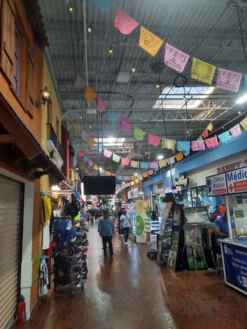
This focus on automobile advertising is seen even in signage traditionally designed for pedestrians. At first glance, Tienda Latina’s storefront in Figure 2 seems pedestrian friendly. There are posters advertising clothing and lottery tickets and mannequins in the storefront windows. However, upon further glance, these posters and storefront mannequins face directly onto a 7-lane highway. Additionally, there is no sidewalk or shoulder for pedestrians to traverse on. Thus, the audience is not, in fact, pedestrians, but rather vehicle drivers and passengers who are idling at the intersection. Here, visual features that mimic walkable-street retail are repurposed for motorists, evidence that even “small-scale” semiotics must negotiate the highway’s automotive conventions.
The same occurs even in Brookhaven, where pedestrian infrastructure has been a recent development focus.

Figure 3. Grady Brookhaven yard signs
Even with smaller signage like yard signs, as seen in Figure 3, these signs are placed strategically near the parking lot entrance and the intersection traffic lights, lending itself to viewing from automobiles. Signage is also heavily catered towards drivers and automobile passengers with the design choices. Many signs are large billboards and exist in competition with each other in a driver’s sightline (Figure 4). This layout of above-eye-level billboards is designed to capture the attention of fast-moving drivers. Despite commitments from city planners to create a safer environment for pedestrians, the emplacement of signage has not reflected this authorship of the conceived space.

Figure 4. Billboards in Brookhaven

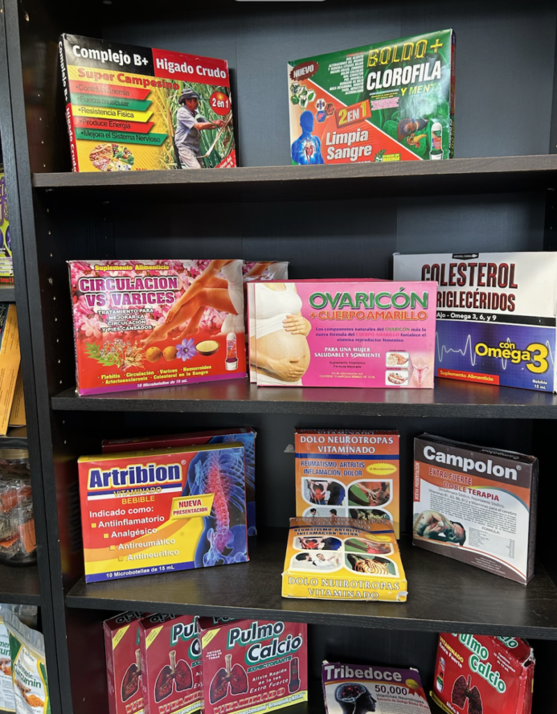
Figure 5. Strip Mall signs in Chamblee
Conclusions and Future Work
There is a disconnect between the Buford Highway infrastructure that city planners envision and the actual perception of this space along the highway. From sign emplacement, we can see the disconnect between city planning efforts for pedestrian infrastructure and the actual infrastructure itself, as well as the way store owners and advertisers adapt. I found Hult’s methodology helpful in observing this disconnect within the built environment. I expanded on Hult’s approach by including more than just highway billboards, and incorporated any signage visible from a car. While Hult focused on the confluence of different discourses that create a linguistically dominant English place within an English-Spanish bilingual space, I focus on the characteristics of signage that create an English-dominant and automobile-focused place within the multilingual, multicultural Buford Highway corridor. There are limitations to the methodology, however. I only looked at the first 50 visible and captured signs within each municipality. While this approach helped scope down my project, I was not able to effectively capture the transition from Brookhaven to Chamblee within my analysis. Additionally, I only captured signage along the south-facing end of the highway. Further work I would do would involve coding the rest of the data and incorporating data from the return back down the highway towards I-85. Additionally, I cross-referenced census data in my data triangulation process. Census data is only an estimate and limits the strength of these findings. One future step is to incorporate interviews with store owners and residents in the area. These would allow me to understand how residents perceive their lived space along the Buford Highway corridor and create a more thorough understanding of placemaking along the Corridor.
References
Ben‑Rafael, E., Shohamy, E., Amara, M. H., & Trumper‑Hecht, N. (2006). Linguistic landscape as symbolic construction of the public space: The case of Israel. In D. Gorter (Ed.), Linguistic landscape: A new approach to multilingualism (pp. 7–30). Multilingual Matters.
City of Brookhaven, Public Works Department. (2025). Buford Highway streetscape project – from Afton Lane to Clairmont Drive. https://www.brookhavenga.gov/publicworks/page/buford-highway-streetscape-project-afton-lane-clairmont-drive
Hult, F. M. (2013). Drive-thru linguistic landscaping: Constructing a linguistically dominant place in a bilingual space. International Journal of Bilingualism, 18(5), 507–523. https://doi.org/10.1080/19313152.2013.746800
Lou, J. J. (2012). Chinatown in Washington, DC: The bilingual landscape. World Englishes, 31(1), 34–47. https://doi.org/10.1111/j.1467-971X.2011.01738.x
Backhaus, P. (2006). Multilingualism in Tokyo: A look into the linguistic landscape. International Journal of Multilingualism, 3(1), 52–66. https://doi.org/10.1080/14790710608668385
Lyons, K., & Rodríguez‑Ordóñez, I. (2017). Quantifying the linguistic landscape: A study of Spanish–English variation in Pilsen, Chicago. Spanish in Context, 14(3), 329–362. https://doi.org/10.1075/sic.14.3.01lyo
Motschenbacher, H. (2020). Walking on Wilton Drive: A linguistic landscape analysis of a homonormative space. Language and Communication, 72, 25–43.
Scollon, R., & Scollon, S. W. (2003). Discourses in place: Language in the material world. Routledge.
U.S. Census Bureau. (2024). American Community Survey 2019–2023 5‑Year Estimates, Detailed Table B02001: Race [Data set]. data.census.gov. https://data.census.gov/table/ACSDT5Y2023.B02001?g=160XX00US1310944,1315172
U.S. Census Bureau. (2024). American Community Survey 2019–2023 5‑Year Estimates, Subject Table S1901: Income in the past 12 months (in 2023 inflation‑adjusted dollars) [Data set]. data.census.gov. https://data.census.gov/table/ACSST5Y2023.S1901?g=160XX00US1310944,1315172
What is Buford Highway? (2011, July 8). BufordHighway.com [Archived page]. https://web.archive.org/web/20110708103911/http://bufordhighway.com/description/
Zhang, H., Tupas, R., & Norhaida, A. (2020). English‑dominated Chinatown: A quantitative investigation of the linguistic landscape of Chinatown in Singapore. Journal of Asian Pacific Communication, 30(1–2), 273–289. https://doi.org/10.1075/japc.00052.zha
Featured image courtesy of Stephen Lee Davis