Bi et al.: Characterizing outdoor infiltration and indoor contribution of PM2.5 with PurpleAir data

Bi, J., Wallace, L. A., Sarnat, J. A., & Liu, Y. (2021). Characterizing outdoor infiltration and indoor contribution of PM2.5 with citizen-based low-cost monitoring data. Environmental Pollution, 276, 116763.

ResearchGate (full text): Link       Elsevier: Link

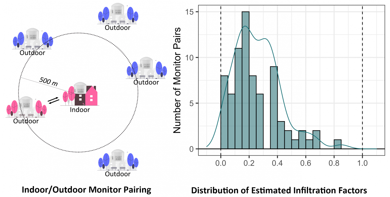
Research in quantifying infiltration factors (Finf), the fraction of outdoor PM2.5 that infiltrates indoors, has been historically limited in space and time due to the high costs of monitor deployment and maintenance. Recently, the growth of openly accessible PM2.5 measurements provides an unprecedented opportunity to characterize Finf at large spatiotemporal scales. In this analysis, 91 consumer-grade PurpleAir indoor/outdoor monitor pairs were identified in California (41 residential houses and 50 public/commercial buildings) during a 20-month period in 2019 – 2020 with around 650k hours of paired PM2.5 measurements. An empirical method was developed based on local polynomial regression to estimate site-specific Finf. The estimated Finf had a mean of 0.26 (25th, 75th percentiles: [0.15, 0.34]) with a mean bootstrap standard deviation of 0.04. The resulting exposure errors (differences between total indoor exposure and exposure due to particles of ambient origin) were plotted as a function of the ambient concentration for the first time. The peak of the exposure errors occurred at low outdoor concentrations < 5 µg/m3 and dropped to nearly zero near 30 µg/m3.


Bi et al.: Incorporating low-cost sensor data into large-scale, high-resolution PM2.5 modeling

Incorporating Low-Cost Sensor Measurements into High-Resolution PM2.5 Modeling at a Large Spatial Scale

A spatially varying calibration and a down-weighting strategy have been proposed to incorporate volunteer-generated low-cost air quality data from PurpleAir sensors into large-scale PM2.5 exposure assessment while minimizing the negative impacts of their significant uncertainty. The inclusion of PurpleAir measurements allowed the exposure estimates to better reflect PM2.5 spatial details and hotspots such as wildfire smokes. The proposed calibration and modeling strategies can be used in regions with insufficient reference-grade measurements to improve air pollution exposure assessment.

Bi, J., Wildani, A., Chang, H. H., & Liu, Y. (2020). Incorporating Low-Cost Sensor Measurements into High-Resolution PM2.5 Modeling at A Large Spatial Scale. Environmental Science & Technology. 10.1021/acs.est.9b06046

Bi et al.: Contribution of low-cost sensor measurements to the prediction of PM2.5 levels

Contribution of low-cost sensor measurements to the prediction of PM2.5 levels: A case study in Imperial County, California, USA

Regulatory monitoring networks are often too sparse to support community-scale PM2.5 exposure assessment, while emerging low-cost sensors have the potential to fill in the gaps. In this study, the contribution of low-cost sensor measurements to high-resolution PM2.5 prediction was evaluated in an exemplary region – Imperial County in California – with a community-operated low-cost network entitled Identifying Violations Affecting Neighborhoods (IVAN). This study shows that the integration of low-cost sensor measurements is an effective way to significantly improve the quality of PM2.5 modeling, while the remaining uncertainty in calibrated sensor measurements still caused apparent outliers in the prediction results. This study highlights the need for more effective calibration or integration methods to relieve the negative impact of remaining sensor uncertainty.

Bi, J., Stowell, J., Seto, E.Y., English, P.B., Al-Hamdan, M.Z., Kinney, P.L., Freedman, F.R. & Liu, Y. (2020). Contribution of low-cost sensor measurements to the prediction of PM2.5 levels: A case study in Imperial County, California, USA. Environmental Research, p.108810. 10.1016/j.envres.2019.108810