
by Randy Gue, Curator of Modern Political and Historical Collections, MARBL
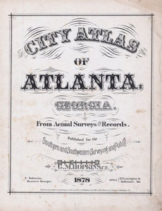
City Atlas of Atlanta, Georgia:
From Actual Surveys and Records,
Manuscript, Archives and Rare Book
Library, Emory University
Did you know you can access some of MARBL’s unique maps and atlases online? Do you want to know how Atlanta was shaped in 1878 or 1928? Are you interested in examining the road network in Cobb County in 1954 when suburban expansion was beginning to reshape the county? Then check out the MARBL Digital Historic Map Collection.
This collection provides a new and innovative way to access our rare maps and atlases. It includes printed maps published before 1923, maps from atlases published before 1923, and some maps printed by state and local governments after 1923. Right now you can find atlases of Atlanta from 1878 and from 1928, a rare plan for Milledgeville, Georgia from 1819, and an 1828 plan for Columbus, Georgia in the collection. In addition, the Georgia Department of Transportation (GDOT) gave us permission to scan and post their county general highway maps. We will be adding to the collection frequently so check back with us often to see what is new.
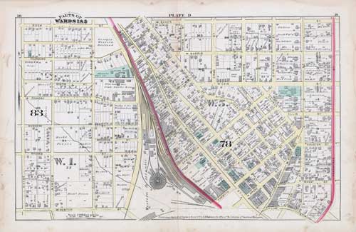
The maps and atlases in the collection are fascinating and useful. For example, I use the 1878 City Atlas of Atlanta Georgia: From Actual Surveys and Records by G.M. Hopkins atlas to help me answer one of the most frequent questions I get about Atlanta. I am always asked why the city’s central business district isn’t laid out on a grid like many American cities. Referring to the atlas, I show them that the historic center of Atlanta is a grid, but the grid is oriented to the railroad tracks that gave birth to the city and not to the cardinal points. You can see this clearly in Plate D: Marietta, Walton, and Luckie streets run perpendicular to the tracks while Spring, Forsyth and Broad streets cross the tracks at ninety degree angles. Atlanta’s streets don’t become oriented to the cardinal directions until Ellis Street.
The 1878 atlas also captures the city at an interesting point in its development. Atlanta grew like kudzu after William Tecumseh Sherman and his soldiers were careless with their matches when they visited in 1864. In 1860, on the eve of the Civil War, Atlanta was home to 9,554 residents. By 1880 the number of residents had risen to 37,409. This remarkable change in population produced dramatic alterations to the configuration of the city. Compare Edward A. Vincent’s “Old Map of Atlanta,” which was included in the 1878 atlas, with the key on the page with the Street Directory. The geography of the city had expanded exponentially by 1878; the land lots in the city now ran all the way north to Seventh Street, south to Rockwell Street, east to Randolph Street, and west to Chestnut Street.
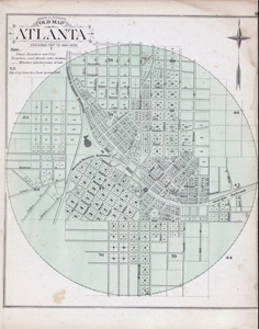
Old Map of Atlanta, Manuscript,
Archives and Rare Book Library,
Emory University
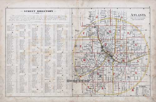
Street Directory from City Atlas of Atlanta, Georgia:
From Actual Surveys and Records, Manuscript, Archives and
Rare Book Library, Emory University
So dive into the MARBL Digital Historic Map Collection and see what you can discover about Atlanta, Georgia, and the South.
For more information about geospatial projects about Atlanta that use MARBL materials, check out Re-Mapping Segregated Atlanta: A Spatial History Project.