Groundwater hydrology, topography, and human influences
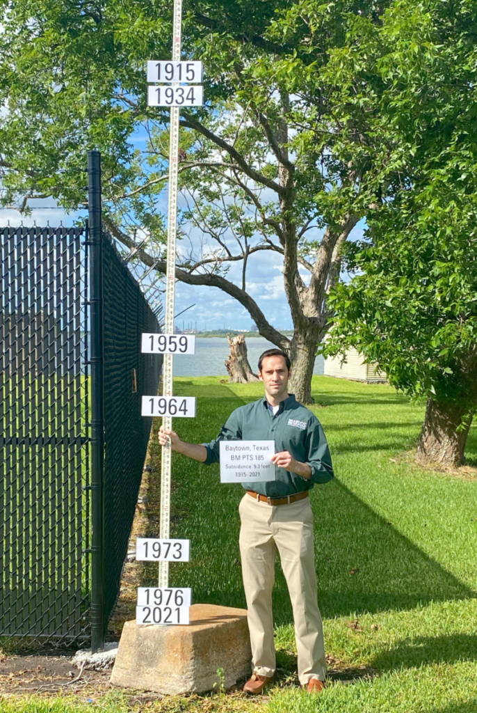
While geomorphic changes tend to be thought of as occurring over centuries or millennia, a few decades of heavy groundwater use can significantly alter the elevation of a city like Houston. Other cities facing this problem include Mexico City and Jakarta (it is most prominent in Southeast Asia). Houston is a major U.S. city on the flat, low-lying coastal plain physiographic province near the Gulf Coast. Its groundwater sources are part of the Coastal Lowlands Aquifer system. When the Houston area’s population began to grow dramatically in the 1940s, so did its groundwater use. By 1975, it is estimated that the land had subsided by about three meters (Petersen et. al., 2020). Groundwater extraction is the primary culprit of its subsidence, though oil and gas extraction and the natural geology also play a role (Khan, 2022).
Groundwater is the water in the phreatic zone, or the area of rock and soil completely saturated by water, below the vadose zone (Bierman and Montgomery, 2020). This water is slowly recharged by percolation of precipitation, so it is not a very sustainable source of drinking water for highly populated areas, compared with surface water, some rivers, and snowmelt. The water authorities of the Houston area have been able to slow its subsidence by switching to surface water when the three main aquifers showed significant depletion in the mid 1970s. However, once groundwater is depleted and land subsides, it cannot realistically be reversed (USGS, 2023b).
Land subsidence has worrying implications for human well being beyond water stress and the simple fact of the land sitting lower. As climate change causes sea level increase, local land subsistence intensifies the sea level rise from the perspective of a coastal city (Khan, 2022). Likewise, climate change is intensifying hurricanes, which are a prominent feature of East Texas and the Gulf Coast. A study of Hurricane Harvey suggested that flooding was associated with subsistence, meaning an area that has been sinking may be at higher risk for dangerous flood levels because their base flow is lower than normal (Miller, 2019). In fact, the storm itself depressed the crust for about a month after the fact (Bierman and Montgomery, 2020), showing the interrelated effects of people, climate change, the water cycle, and geomorphology.
Researchers have developed computer models in order to understand past subsidence and predict how the landscape will change as time goes on. The dynamics of a section of the Gulf Coast aquifer between 1897-2018 are captured by a newly-released model from USGS, the Gulf Coast Land Subsidence and Groundwater-Flow Model (GULF) (Ellis et al., 2023). It is the tenth study of its kind surveying Houston. Groundwater models must take into account fluctuations in water usage, aquifer recharge rates, and the characteristics of sediment overlying the aquifer. GULF is primarily concerned with groundwater availability; it was created as a data tool for the Texas Water Development Board to inform policy decisions (Oklahoma-Texas Water Science Center). Advantages of GULF include higher spatial resolution and new strategies to minimize uncertainty. However, it is not well-adapted to processes that involve horizontal pressure on the aquifer or that happen on a scale smaller than 1 square kilometer. To simplify the problem, GULF also makes certain assumptions about what aspects of the landscape change (or don’t change) in response to stress (Ellis et al., 2023). Researchers justify these assumptions by “history matching” model results with actual field data from the same time period (Ellis et al., 2023). From here, they can determine which factors produce a model result most similar to what was observed historically. While it may appear that much of the science involved in addressing Houston’s subsidence happens in a digital “black box”, in reality field data still has a very critical role to play.
Grace Regnier and Sarah Orozco
Bibliography
- Ellis, J., Knight, J., White, J., Sneed, M., Hughes, J., Ramage, J., Braun, C., Teeple, A., Linzy, F., Rendon, S., and Brandt, J. (2023). Hydrogeology, Land-Surface Subsidence, and Documentation of the Gulf Coast Land Subsidence and Groundwater-Flow (GULF) Model, Southeast Texas, 1897–2018. U.S. Geological Survey Professional Paper 1877. Retrieved from: https://doi.org/10.3133/pp1877.
- Petersen, C., Turco, M. J., Vinson, A., Turco, J. A., Petrov, A., Evans, M., . . . Erkens, G. (2020). Groundwater regulation and the development of alternative source waters to prevent subsidence, houston region, texas, USA. Proceedings – International Association of Hydrological Sciences, 382, 797-801. doi:https://doi.org/10.5194/piahs-382-797-2020
- Khan, S. D., Gadea, O. C. A., Tello Alvarado, A., & Tirmizi, O. A. (2022). Surface Deformation Analysis of the Houston Area Using Time Series Interferometry and Emerging Hot Spot Analysis. Remote Sensing, 14(15), 3831. MDPI AG. Retrieved from http://dx.doi.org/10.3390/rs14153831
- Bierman, P., Montgomery, D. (2020). Key Concepts in Geomorphology. McMillan Learning.
- Texas Gulf Coast Groundwater and Land Subsidence. United States Geological Survey. https://txpub.usgs.gov/houston_subsidence/
- Megan M. Miller, Manoochehr Shirzaei, Land subsidence in Houston correlated with flooding from Hurricane Harvey, (2019) Remote Sensing of Environment, Volume 225, 2019, Pages 368-378. ISSN 0034-4257. https://doi.org/10.1016/j.rse.2019.03.022.
- U.S. Geological Survey. (2023a). “New USGS report provides insights into groundwater and subsidence in the Houston area.” https://www.usgs.gov/centers/oklahoma-texas-water-science-center/news/new-usgs-report-provides-insights-groundwater-and.
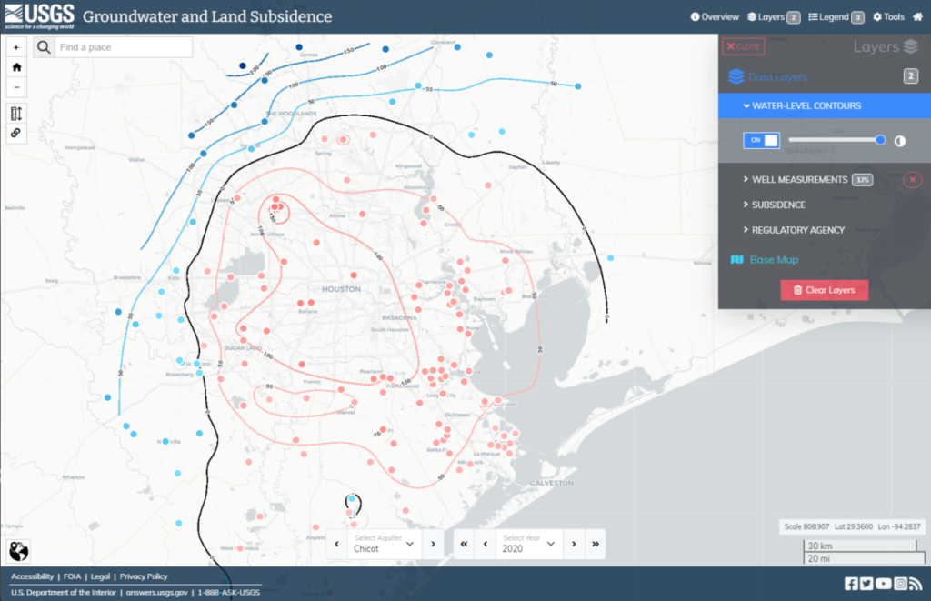
- U.S. Geological Survey. (2023). Texas Gulf Coast Groundwater and Land Subsidence. [Interactive Map]. USGS. https://txpub.usgs.gov/houston_subsidence/archive/viewer.html?view=%7B%22basemap%22%3A%22CartoPositron2%22%2C%22bounds%22%3A%22-97.35809326171875%2C28.70745188935186%2C-93.40301513671876%2C30.652090026760014%22%2C%22controls%22%3A%7B%22aquifer%22%3A%22Chicot%22%2C%22year%22%3A2020%7D%2C%22insetmap%22%3Afalse%2C%22panel%22%3A%7B%22checkbox%22%3A%220%2C1%2C4%2C5%2C6%2C7%22%2C%22range%22%3A%220%3A1.0%2C1%3A1.0%2C2%3A0.7%2C3%3A0.3%2C4%3A1.0%22%2C%22select%22%3A%220%3A0%2C1%3A0%2C2%3A0%2C3%3A0%22%7D%7D