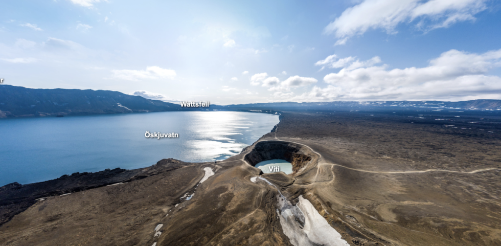
Located in the mountain massif Dyngjufjöll in the eastern fjords of Iceland, Askja is a large basaltic central volcano rising approximately 800 meters above the surrounding lava plain. It consists of at least three calderas: Askja, the main summit caldera with a diameter of about 8 kilometers; the 4-kilometer-wide Kollur caldera; and the youngest 4.5-kilometer-wide caldera, which is now filled by Öskjuvatn lake. In the following paragraphs, we will examine in detail the formation of Öskjuvatn lake, the geothermal crater lake, Viti, as well as the eruption history and recent activities of the volcano.
The Askja volcanic system has been active for at least 200,000 years. Scientists have approximated its eruption history based on tephrochronological records from soil profiles and written records from the last 1000 years. In the last 7000 years, at least 200 eruptions have occurred. During the Holocene, four known types of activity dominated the volcano’s eruption history: effusive basaltic fissure eruptions, which lasted weeks to months; explosive basaltic eruptions lasting months to years; and explosive and/or effusive silicic eruptions, which only lasted days to weeks. Along the Askja Fissure swarm, three types of eruptions were observed: effusive basaltic fissure eruptions, effusive basaltic eruptions on circular vents, and explosive basaltic fissure eruptions (Thordarson, 2021).
The northern part of the volcanic system rarely erupted, producing only one eruption during the last 1100 years. The highest eruption frequency is found in the southern part of the volcanic system, with at least 40 eruptions occurring over the last 1100 years, including one explosive silicic eruption in 1875 CE (1.8 km^3 tephra), which created both the Öskjuvatn crater lake and the Viti crater lake.
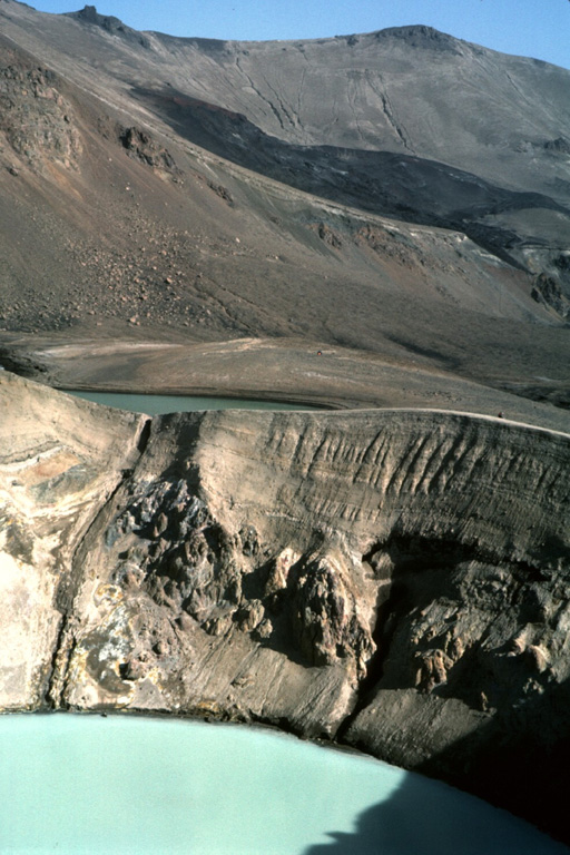
The Öskjuvatn lake is frozen for most of the year. It has a depth of 217 meters and a diameter of approximately 5 kilometers, making its depth even greater than that of the caldera itself. Its surface lies about 50 meters below the main caldera floor, covering an area of around 12 km^2. Historical records prior to the 1875 eruption indicate the absence of free-standing water on the caldera floor, with only a small depression filled with water at the eruption site (Lupi, 2011, p. 152). However, after the eruption, groundwater, rainfall, and snowmelt contributed to the lake (National Park Service, 2023). Presently, the Öskjuvatn lake ranks as the second deepest lake in Iceland (Wikipedia, 2023).
The 200-meter-wide Viti crater, filled with a turquoise lake of indigo color, was located only a few kilometers north of the Öskjuvatn lake. It was formed by phreatic explosions following a major eruption of Askja on March 28-29, 1875. The beautiful blue color of Viti results from the reflection of particles that remained in the crater after its last eruption. As a water source for the lake, moving glaciers ground against the valley walls, creating a fine-grained powder known as glacial flour composed of silts and clays (NASA, 2019). Since the lake receives water from glacier meltwater streams, flours and ash particles became part of the Viti lake. Rather than sinking to the bottom, these fine particles remain suspended in the water. When sunlight reaches the water, these particles absorb the shorter wavelengths, such as purples and indigos, while the water absorbs the longer wavelengths of reds, oranges, and yellows. This results in mainly blues and greens being reflected back to human eyes, giving the lake its distinctive turquoise color.
In September 2021, the Icelandic Meteorological Office (IMO) reported an inflation at Askja. The uplift was centered at the western edge of the Öskjuvatn caldera and exhibited vertical deformation at a rate of about 5 cm per month. The source of the inflation was at a depth of approximately 3 km, most likely resulting from an influx of magma. A week later, IMO raised the Aviation Color Code for Askja to yellow as the inflation rate increased rapidly. At this point, the uplift had reached a total height of 7 cm, and the magma was accumulating at depths of 2-3.5 km. Two months later, despite a total uplift of 40 cm since August 2021, IMO lowered the Aviation Color Code back to green due to the absence of elevated seismicity (Icelandic Meteorological Office, 2023).
Bibliography
Thordarson, T. (2021, September 5). Askja. Catalogue of Icelandic Volcanoes. https://icelandicvolcanoes.is/?volcano=ASK
Lupi, M. (2011). A model for syn-eruptive groundwater flow during the phreatoplinian phase of the 28–29 March 1875 Askja volcano eruption, Iceland. Journal of Volcanology and Geothermal Research, 203(3–4), 146–157. https://doi.org/https://doi.org/10.1016/j.jvolgeores.2011.04.009.
National Parks Service. (2023, April 18). Crater Lakes (U.S. National Park Service). National Parks Service. https://www.nps.gov/articles/000/crater-lakes.htm#:~:text=NPS%20photo-,Introduction,highly%20acidic%20from%20hydrothermal%20fluids.
Wikimedia Foundation. (2023, September 12). Askja. Wikipedia. https://en.wikipedia.org/wiki/Askja
NASA. (2019). How glaciers turn lakes turquoise. NASA. https://earthobservatory.nasa.gov/images/145055/how-glaciers-turn-lakes-turquoise
Icelandic Meteorological office. (2023, August 16). The situation at Askja remains unchanged. https://en.vedur.is/about-imo/news/the-situation-at-askja-remains-unchanged