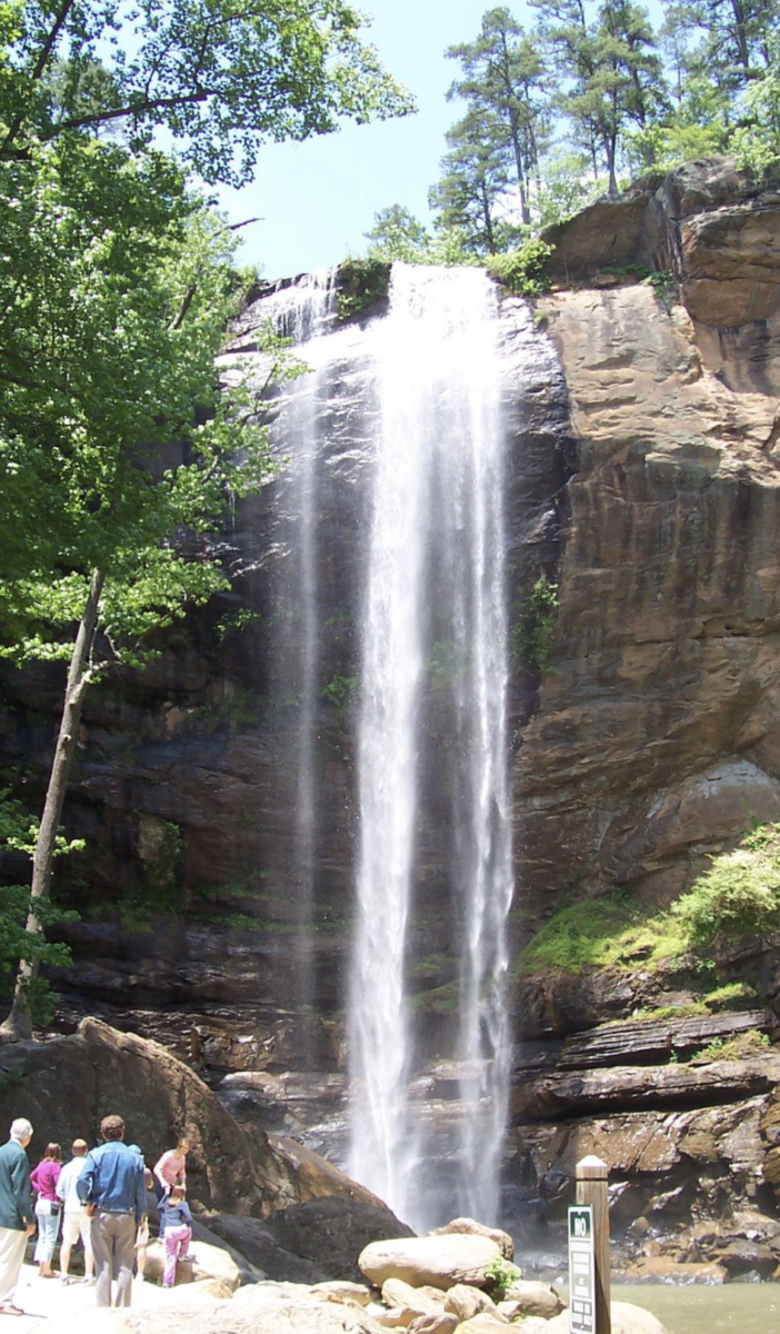
Toccoa Falls is a waterfall with a vertical drop of 186 feet, on the campus of Toccoa Falls College in Stephens County, Georgia. Toccoa comes from a Cherokee word that roughly translates to “beautiful”.
From https://en.wikipedia.org/wiki/Toccoa_Falls.
Toccoa Creak is a stream in Georgia, carrying Toccoa Falls. Kelly Barnes Dam was an eathen embankment dam, utilizing the flow of Toccoa Creek for hydroelectricity operations. The embankment dam was located about 2,000 feet upstream from Toccoa Falls and mostly consisted of residual soils and silt. The dam sat on a foundation of silt and stable biotate gneiss.
In 1977, the Kelly Barnes Dam on Toccoa Creek burst after torrential rains and flooded Toccoa Falls College campus, killing 39 people. The dam was never rebuilt. There is a memorial that stands downstream, where visitors of Toccoa Falls can pay their respects to the dead.
References: Wikimedia Foundation. (2021, April 1). Toccoa Falls. Wikipedia. From https://en.wikipedia.org/wiki/Toccoa_Falls.
Wikimedia Foundation. (2021, April 1). Kelly Barnes Dam. Wikipedia. From https://en.wikidark.org/wiki/Kelly_Barnes_Dam.
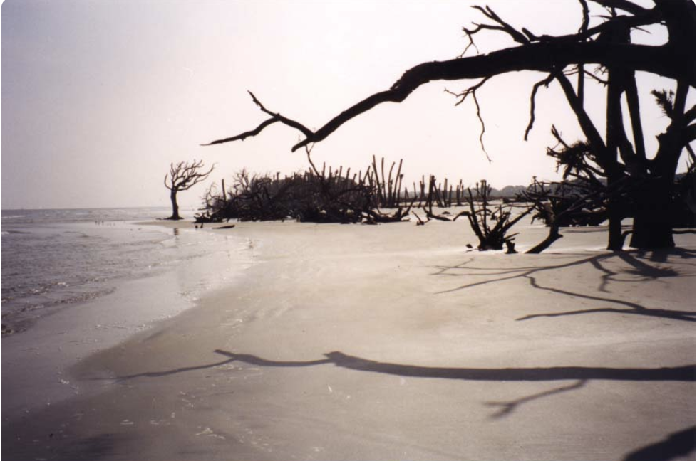
St. Catherines Island is one of the barrier islands of Georgia, located 42 miles south of Savannah, Georgia. The island is ten miles long and ranges from 1 to 3 miles wide. More than half of the island’s acreage comprises tidal marsh, wetland meadows, and ponds. The remaining acreage is densely forested, with pine and live oak being the predominant species.
Photograph by Jason D. Williams. From https://www.georgiaencyclopedia.org/articles/geography-environment/st-catherines-island/.
The history of St. Catherines Island is expansive, so the island was declared a National Historic Landmark in 1969. Today, the island is owned by the St. Catherines Island Foundation, which operates the island’s interior for charitable, scientific, and educational purposes. For this reason, the island is not open to the general public aside from beaches located on the island’s northeast and south sides. The foundation aims to promote the conservation of natural resources, the survival of endangered species, and the preservation of historical sites and expand human knowledge in ecology, natural history, archaeology, and other scientific disciplines. In this capacity, the island serves as a refuge of last resort for endangered species from around the world.
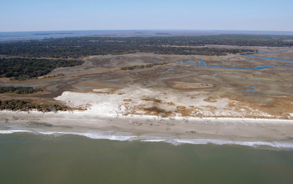
Due to the geographic position of this barrier island and its limited sand supply, sea-level rise has resulted in rapid erosion, causing shorelines to retreat greater than three meters per year. As erosion continues, the nesting habitat of loggerhead turtles continues to diminish. The St. Catherines Island Foundation will continue to monitor sea turtle conservation by addressing nesting habitats threatened by the modern transgression.
Photograph by Brian K. Meyer. From https://www.seaturtlestatus.org/articles/2014/rising-seas-addressing-eroding-habitats-on-st-catherines-island-georgia-usa.
References:
Sherpa guides: Georgia: Coast: Central Coast: St. catherines island. Sherpa Guides | Georgia | Coast | Central Coast | St. Catherines Island. (n.d.). From https://www.sherpaguides.com/georgia/coast/central_coast/st_catherines_island.html.
Wikimedia Foundation. (2021, October 28). St. Catherines Island. Wikipedia. From https://en.wikipedia.org/wiki/St._Catherines_Island.
Hutchinson, B. (2020, April 10). Rising seas: Addressing eroding habitats on St. Catherines Island, Georgia – the state of the world’s Sea Turtles: SWOT. The State of the World’s Sea Turtles | SWOT. From https://www.seaturtlestatus.org/articles/2014/rising-seas-addressing-eroding-habitats-on-st-catherines-island-georgia-usa.
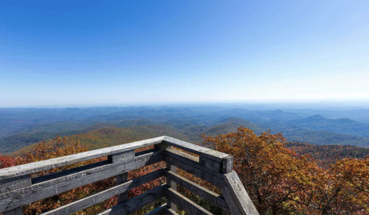
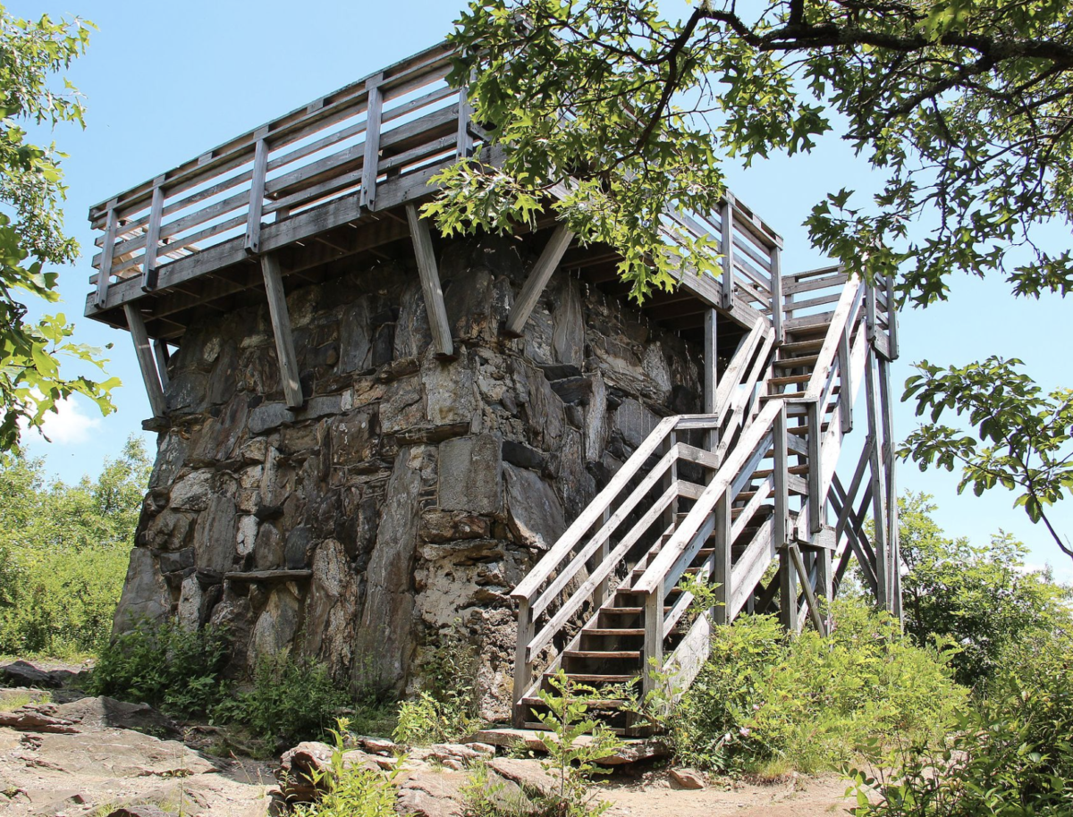
With an elevation of 4,696 feet, Rabun Bald is the second-highest peak in Georgia, located immediately southeast of Sky Valley, Georgia. Its parent range is the Blue Ridge Mountains, a physiographic province of the larger Appalachian Mountains range. Approximately 320 million years ago, North American and Europe collided, pushing up the Blue Ridge and forming Rabun Bald.
From https://www.atlantatrails.com/hiking-trails/rabun-bald-bartram-trail/.
The United States Forest Service operated a fire tower on Rabun Bald until the early 1970s. After the fire tower was taken out of service, the stone base was left intact and a Youth Conservation Corps crew a railed wooden observation platform. Today, Rabun Bald is a tourist attraction for hikers especially. The observation tower on Rabun Bald’s summit provides hikers with views that, on clear days, extend for more than 100 miles. The hike to the top of Rabun Bald connects with the Bartram Trail system, which passes over the top as it winds through northeast Georgia for 37 miles.
From https://en.wikipedia.org/wiki/Rabun_Bald.
References: Wikimedia Foundation. (2020, October 16). Rabun Bald. Wikipedia. From https://en.wikipedia.org/wiki/Rabun_Bald.
Wikimedia Foundation. (2021, November 14). Blue Ridge Mountains. Wikipedia. From https://en.wikipedia.org/wiki/Blue_Ridge_Mountains.
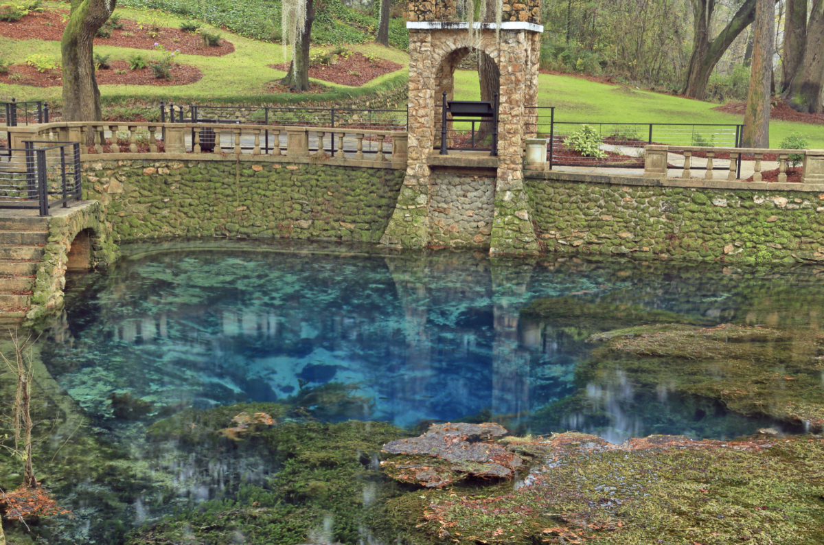
Radium Springs, located on the outskirts of Albany in Dougherty County, Georgia, is best known as one of the seven wonders of Georgia. The water contains trace amounts of radium; hence, the coined name “Radium Springs.” Before discovering radium in the water in 1925, the site was historically known as “Blue Springs.” A casino was built, which was flooded in the 1990s and demolished in 2003. Today, Radium Springs is a tourist attraction that features a park with a restored terrace, new sidewalks, a casino garden, and gazebos.
Radium Springs was once reported as the largest spring in Georgia, flowing at 70,000 gallons per minute and emptying into the Flint River. Something to note is that the groundwater levels affect if Radium Springs flow or dries out. The water of Radium Springs empties into the Flint River, which flows through a channel in limestone rock above the Floridan Aquifer, creating an extensive underwater cavern system.
In the picture below, Radium Springs flows bright blue waters when Floridan Aquifer levels are high enough.
Alan Cressler, USGS. Public domain, https://www.usgs.gov/media/before-after/groundwater-levels-affect-if-radium-springs-ga-flows-or-dry
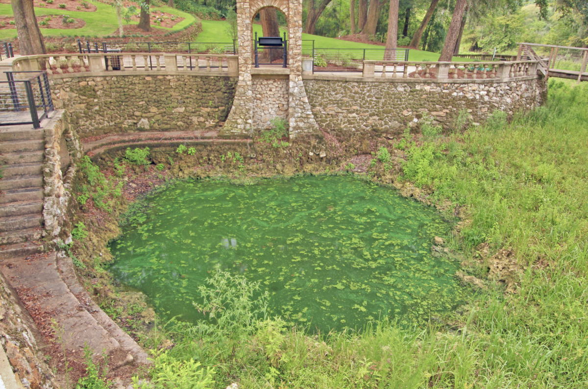
Comparatively, the picture below shows Radium Springs in 2012 when Georgia was experiencing drought conditions and, in turn, groundwater withdrawals. The flow in Radium Springs stopped due to falling water-table levels in the aquifer supplying water to this spring.
Alan Cressler, USGS. Public domain, https://www.usgs.gov/media/before-after/groundwater-levels-affect-if-radium-springs-ga-flows-or-dry
References: Wikimedia Foundation. (2021, July 8). Radium Springs, Georgia. Wikipedia. From https://en.wikipedia.org/wiki/Radium_Springs,_Georgia.
USGS. Groundwater levels affect if Radium Springs, GA flows or is dry. From https://www.usgs.gov/media/before-after/groundwater-levels-affect-if-radium-springs-ga-flows-or-dry.
Radium Springs Gardens. Discover Albany GA. (n.d.). From https://visitalbanyga.com/attraction/radium-springs-gardens.