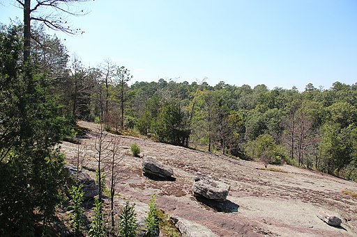
Panola Mountain is an 100 acre granite outcrop located near Stockbridge, GA on the border of Henry County and Rockdale County. It rises 946ft above sea level. It is similar to Stone Mountain and Arabia Mountain but smaller and has not been quarried at all. Because of the pristine state of the outcrop, visitors must register for guided hikes in order to see the top of the mountain. It is part of the Arabia Mountain National Heritage Area and was designated a National Natural Landmark.
Granite outcrops are formed through the intrusion of molten granite into rock below the surface. Over millions of years, erosion has removed the overlying rock which exposes the granite and creates granite outcrops like Panola and Stone Mountain. Stone Mountain, Panola Mountain, and Arabia Mountain are all within fifteen miles of each other but each is a separate form of granite which reveals that they are all different types of rock intrusions. Weathering affects these outcrops and produces specific rock patterns. The most common one is exfoliation which is when exposed outcrops break into parallel sheets. Environmental conditions on these outcrops are much different from the surrounding forest. Temperatures are higher and evapotranspiration is much lower. Most precipitation runs off. Granite outcrops are described as “islands of desert embedded in a sea of deciduous forest” (Wyatt, 2005).
Atop of Panola Mountain, you can find solution pits, or vernal pools, which are shallow depressions that temporarily fill with water, supporting endemic species and gradually building up a soil harbour. There are unique species that only exist on these Piedmont granite outcrops and specifically in these solution pits. Eventually these pits will be filled with vegetative communities. It will take over 1000 years for bare rock to transition into a oak-pine-hickory forest.
It sits within Panola Mountain State Park, which encompasses Panola Mountain as well as Vaughters Farm which is located 7 miles away. There is a nature center at the Highway 155 entrance along with picnic shelters and a playground. There is a Lakeside Area around 45-acre Alexander Lake, with a path surrounding it as well as a rentable Pavilion. There are 35miles of trails throughout the park. There is also an archery range and hike-in primitive campsites. Vaughters Farm was the last operating dairy farm in DeKalb County and remains preserved as a historical site.
Bibliography
Panola Mountain. (2020, August 28). Retrieved from https://en.wikipedia.org/wiki/Panola_Mountain
Panola Mountain State Park. (n.d.). Retrieved from https://gastateparks.org/PanolaMountain
Wyatt, R. E., 2005. Granite Outcrops. Retrieved from https://www.georgiaencyclopedia.org/articles/geography-environment/granite-outcrops/
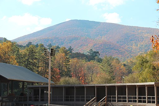
Blood Mountain, at 4,458ft, is the highest peak on the Georgia Appalachian trail (but not the highest peak in Georgia or on the trail). It is also the high point of the Apalachicola River watershed via the Chattahoochee River and on the border of Lumpkin County and Union County. The name of the mountain is thought to have either originated from a bloody battle between Cherokee and Muscogee Native Americans or from the reddish color of the lichen near the summit.
The Georgia Blue Ridge Mountains make up the southernmost part of the Appalachian mountain range and includes Blood Mountain. It is a part of the geologic system that extends from the Blue Ridge province of Virginia. The mountains were formed over 500 million years ago. A collision between the North American and African plates 300 million years ago caused massive plates of rock to pile up. However since then, erosion has withered away the Georgia mountains.
This portion of the Appalachian Trail is the most heavily used portion of the AT in Georgia. There is a rock shelter at the peak which is a two room stone cabin built by the CCC in 1934. On the bottom eastern side there is a hostel and store at Walasi-Yi Interpretive Center. Walasi-Yi was originally a logging company’s log cabin and was expanded by the CC into a larger stone building. It is the only place where the AT passes through a man-made structure.
The Blood Mountain Wilderness contains 7,800 acres and was dedicated in 1991. It is within the Chattahoochee National Forest and the Chestatee Wildlife Management Area. It consists of mostly second-growth upland and cove hardwoods and the forest is around 60-years-old. Notable wildlife includes deer, grouse, wild turkeys, squirrels, black bears and racoons. There is a lot of hunting and trout fishing within it as well as old logging roads.
Bibliography
Seabrook, C. 2006. Blue Ridge Mountains. Retrieved from https://www.georgiaencyclopedia.org/articles/geography-environment/blue-ridge-mountains/
(n.d.). Retrieved from https://www.n-georgia.com/blood-mountain-wilderness.html
Blood Mountain. (2021, October 05). Retrieved from https://en.wikipedia.org/wiki/Blood_Mountain
Taken by Bryce Tuten, https://www.flickr.com/photos/savannahgrandfather/18549478358/in/photostream/
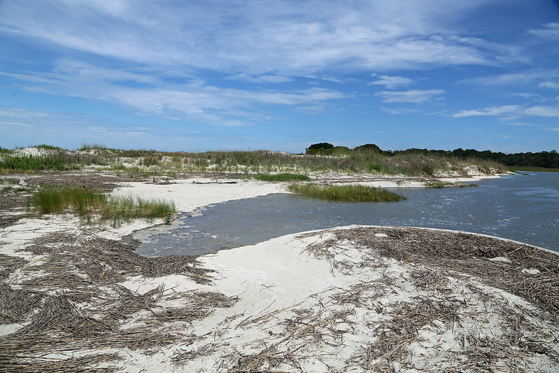
Wassaw Island is the second Georgia barrier island located just south of Tybee Island. It is north of Ossabaw Island. It is a National Wildlife Refuge and was designated on October 20, 1969. The Refuge is 10,053 acres with dunes, live oak and slash pine and salt marshes. There are 20 miles of dirt roads and 7 miles of beach. The island is about 8.5km long and 1.2km wide. It is only accessible by boat and you must use your own boat to reach the refuge. It is open from public from sunrise to sunset.
Geological History
Unlike other Georgia Barrier Islands, Wassaw was formed less than 1,000 years ago. Skidaway Island, which lies inland of Wassaw Island, was a coastal barrier island during the Pleistocene Epoch but the formation of Wassaw Island landlocked Skidaway.
Hurricanes did not affect the barrier islands severely until Hurricanes Matthew (2016) and Irma in 2017. The 1893 Sea Islands Hurricane impacted Wassaw Island by creating an unusually tall coastal sand ridge which is now covered by maritime forest. Additionally, the ridges seen in the maritime forest on the southern tip is indicative of a regressional period of development of Wassaw Island, which means that the island was building seaward at some point. There is a tree boneyard that has been left behind as the long-shore drift and sea level rise erode away the north end of the island and brings sand to the southern tip.
Ecological History
Wassaw Island is a refuge for egret and heron rookeries, wading birds, and loggerhead sea turtles. The salt marsh is home to a large alligator population as well. The ecosystems on Wassaw Island include salt marshes, maritime forests, beaches and freshwater ponds. It is 76% salt marsh and 24% upland, which includes non-salt marsh areas. The salt marsh separates Wassaw Island from Skidaway Island. Wassaw Island is one of the only islands to have never been clear cut for timber. Thus, its upland areas are filled with old-growth maritime forest.
A collaboration between the Savannah Science Museum, the Wassaw Island Trust (founded by the Parsons family who owned the island), and the US Fish and Wildlife Service, the Caretta Research Project was started in 1972. The project monitors the loggerhead sea turtle population on Wassaw island by collecting demographic information. The project protects nests to secure safe incubation and encourage hatchling production. Wassaw Island receives some of the highest densities of loggerhead nests in the state, which is why it is central to the CRP. Since the start of the CRP, they’ve seen an 8-fold increase in Loggerhead nesting. Every year, from mid-May to Labor Day, a two person staff and six volunteers inhabit the island and patrol the beach. To participate in the program, one can pay a $795 fee which covers meals and accommodations in a Parsons cabin.
Human History
There is very little development and management on the island, which can be attributed to both the geological youth of the island which reduces the Native American history on the island as well as limited development by European colonizers. Native American artifacts have been found on the island dating back to 500-600AD
In 1846, 300 slaves were brought from a plantation in Liberty County, GA to die in isolation in attempt to prevent a cholera epidemic. All the slaves are believed to have died and were buried in unmarked graves.
Little Wassaw Island is the only island owned by a formerly enslaved Black person. Anthony Odingsell was given Little Wassaw Island by his owner, Charles Odingsell, along with nine slaves who were to work the land. The proceeds from the land were intended to fund Anthony’s education. In 1860, Anthony Odingsell owned 2,000 acres of land, 13 slaves, 35 cows, 50 sheep, and 75 pigs. He died January 15, 1878 at the age of 94, surviving both the Civil War and Reconstruction. He held onto Little Wassaw throughout this period.
During the Civil War, the island was occupied by Confederate and Union troops. Cannon balls have been found along the northern end along with an unmarked soldier’s grave.
During the Spanish American War of 1898, Battery Morgan was built on the northern tip to protect Savannah. It was originally located in the coastal dunes but longshore drift and sea-level rise have relocated the ruins of the Battery over 50m offshore.
George Parsons, born in 1826 in Maine, was a businessman with dealings in southern cities including Savannah. He purchased Wassaw Island in 1866 as a bridal gift for Sarah Eddy Parsons. A family compound was built in the center of the island. Guided by conservation interests, the family sold Wassaw Island to the Nature Conservancy of Georgia for $1 million under three conditions: 1) the island would remain in its natural state 2) no bridge would connect it to the mainland 3) 180 acres would be retained by the Parsons family including the housing compound.
Bibliography
About the Refuge – Wassaw – U.S. Fish and Wildlife Service. (n.d.). Retrieved from https://www.fws.gov/refuge/Wassaw/about.html
Johnson, W. B. (1980). Free Blacks in Antebellum Savannah: An Economic Profile. The Georgia Historical Quarterly, 64(4), 418–431. http://www.jstor.org/stable/40580706
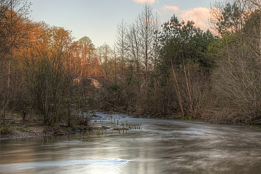
The Towaliga River is a 52.3mi long tributary river that feeds into the Ocmulgee River in Central Georgia. It rises near the town of Hampton in southern Henry County and flows southeast through Henry County, Spalding County, Butts County and Monroe County. In Monroe County, the river joins the west side of the Ocmulgee River near Juliette, GA. The Ocmulgee River merges with the Oconee River to form the Altamaha River and flows into the Atlantic Ocean. The upper areas of the Ocmulgee River, which includes the Towaliga River, have been impacted by pollutants from urbanization.
Where the name “Towaliga” comes from is quite contested. An earlier spelling of the name was Towelagee. Some suggest that it comes from the Creek words, “Tawa laigi”, meaning “Sumac Place”. Others believe it means “About Trees” or “An Old Place”. It also has been suggested to come from the Muskogean word, “Towlaggie”, meaning “Roasted Scalps” or the place that war was stopped in order to dry warrior’s scalps. There was also an early settlement which was seven miles west of Jackson, GA that was called Towaliga.
Along the river, there are multiple notable landmarks. Firstly, there are two reservoirs in Henry County that were created through damming the Towaliga River. Both are owned and operated by Henry County Water Authority. The first is Cole Reservoir (Upper Towaliga Reservoir) which is 1,100 acres and can hold 6.0 billion gallons of water. Exclusive recreational use rights are given to the gated community, Heron Bay, which lies east of the Reservoir. The second is Robert W. Strickland Reservoir (Lower Towaliga Reservoir) which is 121 acres and can hold 135 million gallons of water. Further down the river is High Falls Lake, High Falls State Park, and High Falls. The park is 1,050 acres and within the park, there are trails, campsites, yurts, and picnic areas. Before High Falls Lake, the river is more of an alluvial channel but after the lake, the river become a bedrock channel and wider.
Bibliography:
High Falls State Park. (n.d.). Retrieved from https://gastateparks.org/HighFalls.
Krakow, K. K. (1994). Georgia place-names: Their history and origins. Winship Press.
Meyer, J.L., Loeffler, G. 2009. River Basins. Retrieved from https://www.georgiaencyclopedia.org/articles/geography-environment/river-basins/
Reservoirs. (2021). Retrieved from https://www.hcwa.com/resources-and-facilities/reservoirs.cms.