Ellison’s Cave

Image Source: Thomson200, CC0, via Wikimedia Commons

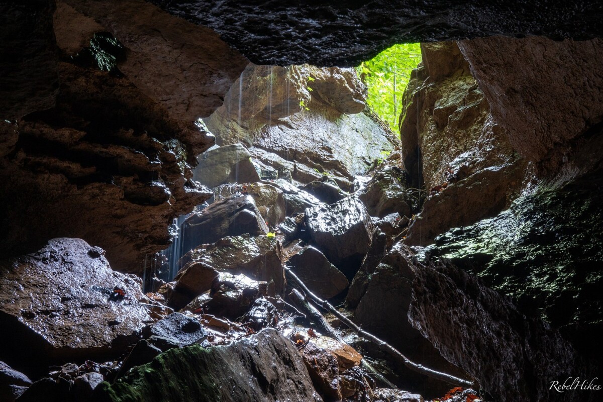
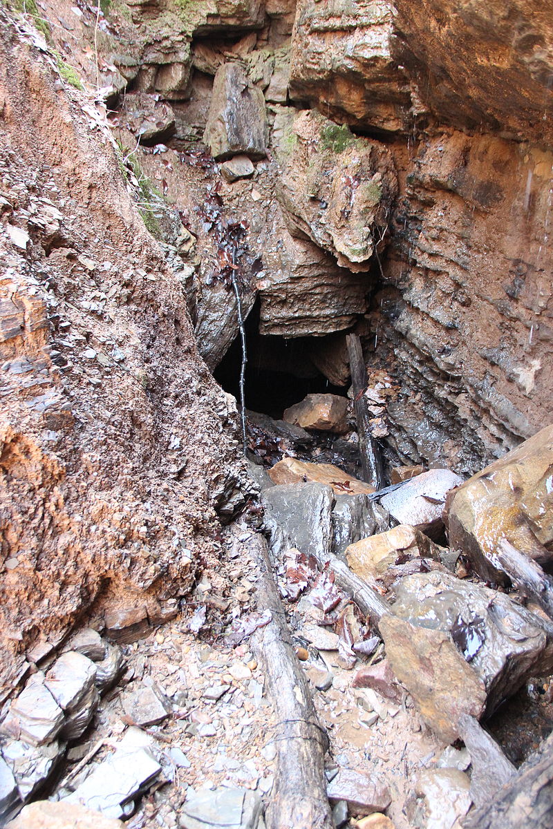
Ellison’s Cave is located is Northwest Georgia, in the Crockford-Pigeon Mountain Wildlife Management Area in Walker County. With a total length of 64,030 feet, Ellison’s Cave is almost twelve miles long and measures 1,063 feet deep—one of the largest caves in the United States. It contains the two deepest cave drops in the country, named “Fantastic” and “Incredible,” and measuring up to 586 and 440 feet deep, respectively.

It was formed from the dissolution of limestone bedrock by acidic groundwater, which in northwest Georgia dates to the Paleozoic Age. An exploration of the cave in 1968 led to a unique geological discovery: there is a semi-active fault along the floor of the cave, that can be visible from the bottom of the cave’s massive pits. The orientation of grooves in the cave’s walls give it away to be a lateral fault, one that moves horizontally. Piles of debris and pulverized rock accumulate on the floor of the cave from the grinding of fault planes. Although the fault is surprisingly active for this area of the country, most have its movements have been small enough to not yet pose any risk to the structure of the cave. Because of its impressive drops, Ellison’s cave today is frequently visited for hiking and by cavers, who flock to the region where Georgia, Alabama, and Tennessee meet for some of the world’s best caving.


Sources:

Elkins, J. T. and L. B. Railsback. (23 Jul. 2018.) Caves. New Georgia Encyclopedia. Web. Retrieved 15 November 2021 from https://www.georgiaencyclopedia.org/articles/geography-environment/caves/

Palmer, A. (Dec. 2009). Cave Exploration as a Guide to Geologic Research in the Appalachians. Society Bulletin, 71(3): 180-192. DOI:10.4311/jcks2008es0042

Image Source: RebelHikes, CC BY-SA 4.0 <https://creativecommons.org/licenses/by-sa/4.0>, via Wikimedia Commons

Brunswick-Altamaha Canal

Image Source: Bubba73, CC BY-SA 3.0 https://creativecommons.org/licenses/by-sa/3.0, via Wikimedia Commons

The Brunswick-Altamaha Canal is a twelve-mile-long canal in southeast Georgia that was built in order to connect Brunswick, Georgia to the Altamaha River. The canal connects to the Turtle River in Brunswick, where it was intended to help trade goods from Brunswick be transported inland and further north faster. Construction began on the canal in 1836, however by the time it was completed and opened in 1854, the rapid introduction of rail transport made it obsolete. The canal follows a north to south depression that has been determined to be in the trough of an old Pleistocene shoreline formation called the Princess Anne. The bottom of the tough is about ten to fifteen feet below sea level, while ridges on the sides of the trough reach about thirty-five feet. The middle section of this trough was a lagoon in Pleistocene times, yet in modern and recent historical times has been a freshwater swamp.

The drainage systems of both the Altamaha and Turtle Creek reached into this trough before the canal was constructed between them. Yet the canal’s builders had plans in place to alter the existing drainage patterns by keeping the water’s saline, not fresh like the Altamaha, and keeping the canal at a high tide level at all times, removing the effect of tides. The corridor around the canal contains three different types of plant landscapes: estuarine marsh, freshwater wetland, and oak-pine upland.

Today, the canal flows through forests and natural landscapes, as well as rural developments, subdivisions, and industrial areas as it moves further south towards Brunswick. The current condition of the canal is somewhat degraded; about a mile of it has been filled in, and in many parts it is filled with silt, clogged by debris, or overgrown with aquatic plants. Because the canal exists in this degraded state today, it is often stagnant due to the many impediments to drainage and tidal flow. Overall, the canal represents an important historical moment for southeast Georgia at a time when the country was rapidly developing, which unfortunately has led to a modern-day canal in an abandoned state.


Source:

Brunswick—Glenn County Join Planning Commission. (August 1981). Brunswick Altamaha Canal Study. Web. Retrieved 15 November 2021. https://glynncounty.org/DocumentCenter/View/3386/Robinson-Fisher-Associates?bidId=

Duke’s Creek Falls

Image Source: Dsdugan, CC BY-SA 4.0 https://creativecommons.org/licenses/by-sa/4.0, via Wikimedia Commons

Dukes Creek Falls is a 150-foot waterfall located at the confluence of Davis Creek and Dukes Creek in the Northeast corner of Georgia, just west of the city Helen. At this point where the creeks converge, Davis actually falls directly into Dukes, creating the Dukes Creek Falls. Duke’s Creek averages around 25 feet wide, and in addition to the larger falls includes a number of other cascades and small falls, all with very swift moving water. The area has a significant amount of exposed bedrock, reminiscent of a typical fast-moving mountain stream. The land around the creek starts out flat and begins to plunge into a gorge near the falls.

Duke’s Creek Falls is located in a historically notable area because it is rumored to be the first place that the Gold Rush in Georgia began. Additionally, the area also contains evidence of historical logging activity and some home sites, according to the U.S. Forest Service. Helen, a state and region-wide tourist attraction draws a number of visitors into this site, and the falls have recently become a very popular spot amongst hikers and walkers, with a number of boardwalks and viewing platforms that now make the waterfall area very accessible.


Sources: 

US Forest Service. (n.d). Appendix D: Wild And Scenic Rivers. Chattahoochee-Oconee National Forests. Web. Retrieved 15 November 2021 from https://www.fs.usda.gov/Internet/FSE_DOCUMENTS/fsm9_028728.pdf

Georgia State Parks. (n.d.) Smithgall Woods State Park. Web. Retrieved 15 Nov. 2021 from https://gastateparks.org/sites/default/files/parks/pdf/trailmaps/SmithgallWoods_TrailMap.pdf

Alcovy River Swamp

Image Source: Georgia Wildlife Federation

The Alcovy River Swamp is located adjacent to the Alcovy River, in north-central Georgia. The Alcovy river is a 69 mile long tributary of the Ocmulgee River, and part of the Altamaha watershed. It originates near Lawrenceville, Georgia, and flows south, eventually emptying into Lake Jackson. On its track near the city of Covington, is the Alcovy River Swamp. The swamp is now part of a nature conservancy, called the Alcovy Conservation Center, which has trails that allow people to explore the swamp and surrounding forest. Another waterway, Cornish Creek, is a tributary that runs north to south, meeting the Alcovy River, where the swamp rests in the corner between the two. The wetlands are surrounded by the Cornish Creek floodplain, so many plant species that can be found here are those that can thrive underwater for periods of time, such as river cane, sweet gum, musclewood, and river birch.

The Alcovy River Swamp is not without human influence. In the 1960’s, Cornish Creek was channelized to prevent flooding. The bottom of the river was dredged to scoop out sediment, which removed many natural bends found in the river, making it reminiscent of a drainage ditch. The creek still has not returned to its natural form, as during storms water is able to travel through it too quickly, eroding the banks and transporting large amounts of sediment downstream, where it threatens water quality and aquatic habitats near the swamp. This land also bears the mark of agricultural use. The forest surrounding the swamp was used as farmland in the mid-1900’s, which is evident from the way in which the land has been shaped into terraces, which helped maximize farming area and prevent erosion.

Like other wetlands, the Alcovy River Swamp is a valuable natural feature because of the incredible biodiversity it harbors, its ability to filter out pollutants and sediments from water sources, and because it prevents downstream flooding by storing excess water.


Sources:

Georgia River Network. (n.d.) Ocmulgee River. Web. Retrieved 15 November 2021 from https://garivers.org/ocmulgee-river/.

Georgia Wildlife Federation. (n.d.) Alcovy Conservation Center. Web. Retrieved 29 November 2021 from https://gwf.org/acc/.

Georgia Wildlife Federation. (n.d.) Discovering the Alcovy River Swamp and its surrounding habitats. Web. Retrieved 15 November 2021 from https://gwf.org/wp-content/uploads/2017/04/ACCtrailguide.pdf.

Snoflo. (n.d.) Alcovy River. Web. Retrieved 15 November 2021 from https://snoflo.org/river-levels/alcovy-river.